Patchwork Quilt, U.S.A.: a future within biking distance
Saturdays, henceforth, are declared car-free
Imagine your government has declared that beginning next weekend, no passenger vehicle may be operated from midnight to midnight on Saturdays. Their intention is to save gasoline in the face of shortages resulting from the weeks-long closure of the Strait of Hormuz. If it was your government that caused the closure, you may be tempted to laugh sarcastically or rage. Stick with me. Imagine car-free Saturday has been given by order of the Peaky Blinders if it helps. Say it in Arthur’s voice to channel your rage. Your government (or the Shelby Company Limited) has committed to a stimulus package similar in magnitude to the American CARES Act.1 Eligible adults may select any bicycle from this catalogue including accessories like milk crates, baskets, or saddle bags, and credits are available for dependents that can be applied to children’s bikes and cargo bikes for families. Logistics companies have been contracted to deliver these items to your home.
Now the question is: what can you get up to? To help you plan your first car-free Saturday, there is a map widget below. You can enter your home address or double click on any point on the map. It will show you the area accessible within 20 minutes’ ride of that location. You may vary how long you are willing to ride. On the right-hand side you can toggle on different categories of destinations. (The colored dots are not comprehensive so don’t be surprised if you see additional points of interest on the map without a dot.) Remember, there are no cars whizzing by. You can ride any of the roads and be assured that the scariest thing you might see is Tommy Shelby on a black horse.
Have a look, make a mental note of what you learn, take a screen shot if you are willing. Feel free to inspect other locations, perhaps where you grew up. One final detail, I’m giving a rough estimate of walking and driving times to put the size of the bikeable region into context for those of you who don’t cycle often. Ok see you again on the flip side!
The flip side
So, how’d it go? I seriously hope to hear your thoughts. Given the size of my readership, there is a good chance you know how to reach me. If you got lost and wound up here on your own, my email address is at the bottom of this page.
If, like me, you are one of the 80% of Americans living in urban areas2, I’d bet you were pleasantly surprised by how many points of interest are accessible by bike, at least on car-free Saturdays. Astonishingly, nearly half of all trips Americans make by car are less than 3 miles long, in other words, a breezy 20-minute bike ride.3 American cities are notoriously sprawling and car-centric, but it is the car-centrism, not the sprawl, which prevents us from popping around town on our bicycles.
Marco! Polo!
Let me illustrate this point with an analogy to the computer game Age of Empires II, which I used to play as a kid. In AoEII, players build up a civilization from a small settlement into an empire by collecting resources to build infrastructure and mobilize an army against the other players vying for territory. If played properly, a black layer covers the entire map save for where your humble village is initialized. To find resources to build up your empire, you must send a scout on horseback into the darkness, a harrowing task given that you do not know where nearby enemies lurk and to what degree they have already mobilized.
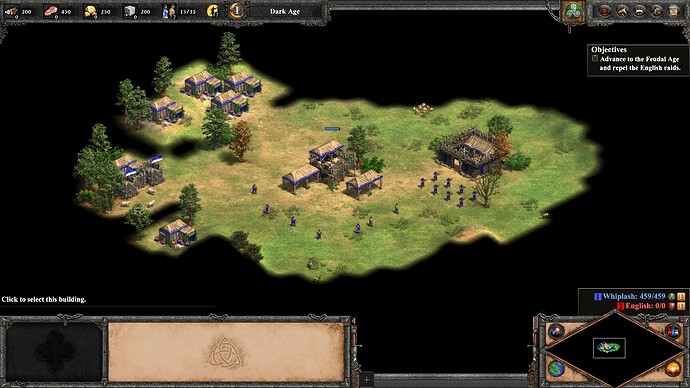
This captures how it feels to explore most American cities by bicycle. You ride out towards a park, or grocery store, or movie theater white-knuckling your handlebars, dodging 3-ton Ford F150s, and praying you don’t make a wrong turn and find yourself on a highway with 50+ MPH traffic, or as they are called in California, roads. A breezy 20-minute ride feels like an anxious hour. If you are lucky, you will have discovered one sort-of-safe route through the darkness, but more likely you will throw your tear-soaked bike into storage in defeat.
In AoEII, the cheat codes “marco” and “polo” instantly made the entire map visible, giving players assurance to venture out in all directions and avoid danger without the need for tedious and risky scout missions. I designed the map widget with this cheat code in mind, to imagine a counterfactual world in which you don’t have to think twice about your safety as you head out on a bicycle. Of course, this comes at a great cost of inconvenience on car-free Saturdays, but we need not outlaw cars to make our imagined world reality. We should instead install comprehensive bicycle networks, joining cities like Copenhagen, Amsterdam, Utrecht, Paris, and Montreal.
A comprehensive bicycle network is one that connects virtually all points in a city via safe routes such that the person setting out on bike does not have to think or worry at all that they’ll reach their destination in one piece. Copenhagen, which I had the pleasure of visiting, has a comprehensive bicycle network. After a hour or two starring destinations on Google Maps, and a few minutes chatting with the hotel concierge about safety tips and norms – hand signals, no left turns, pass on the left, how to use a wheel lock – I was off. I made it everywhere I wanted to go and discovered even more along the way. Their bicycle network consists of a combination of raised, separated lanes on major corridors (think a second sidewalk), shared lanes on side streets with extremely calm local car traffic, and dedicated bike paths galore, all seamlessly, continuously woven through residential areas and commercial areas, pleasant parks and hopping downtown centers. Basically, it’s impossible to get off piste, the same expectation we Americans have of our road networks.
A common rejoinder states that American cities are simply too sprawling for bicycles to make sense. I hope the map widget and an imagined car-free Saturday showed some of the cracks in this argument. At the end of this article, I will sketch a pro-bike vision of the future which I call Patchwork Quilt, U.S.A.
Before that, I’ll argue why we should even bother with this endeavor beyond the incontrovertible truths that riding a bike is fun, safe, and convenient. Car-centrism is a major culprit in the triple crisis facing American cities. By effectively mandating the car as the only transportation option in our cities, we fritter away critical resources: energy, space, and cash, three inputs to the pursuit of happiness made scarce by our own hand.
The crisis of energy: balancing the budget
All the good stuff in life requires energy. This is roughly demonstrated in the chart below which plots power consumption per capita against GDP per capita.
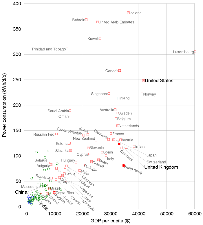
This, and many other important facts are clearly discussed in Sustainable Energy without the Hot Air (SEWTHA) by David MacKay, which you can access online for free.4 I will adopt MacKay’s practical, quantitative attitude toward the subject here, leaving out “Hot Air” in the sense of B.S., but also the subject of climate change, which is decidedly not B.S., but which we do not need for the present discussion. This is just a business discussion.
All businesses, from the lemonade stand to the household to the multi-national corporation, stand upon the same basic foundation, a single number counting how much earned less what was spent. Though the management of a business may feature many complexities – multiple stakeholders, supply chains, equipment – and while a growing business can for years defy gravity, in the end, for the business to sustain, that single number, the bottom line, must be positive. Sustainable energy is a business. It has complexities ranging across physics, chemistry, and climatology that would make supply chain managers at Amazon, Apple, or Toyota cower in fear, but it too boils down to the bottom line which differs only in that the measured currency is energy, not cash.
The central figure from SEWTHA shows an energetic profit and loss statement.
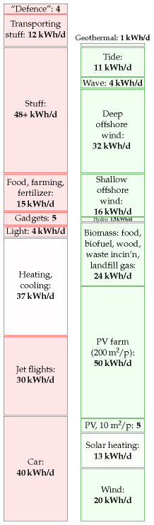
Energy is measured in units of kilowatt hours per person per day (kWh / d). For reference, if you left a 40-watt lightbulb on for 1 day, you will have used about 1 kWh (40 x 24 ~ 1,000). Energy consumption in red is categorized by use and an estimate of in principle sustainable energy generation is shown in green. There are several caveats. MacKay’s discussion centers around a British citizen of above-average means, and it is by now slightly outdated. However, his analysis is from first principles and has held up fairly well over time. Things will vary from country to country of course. For example, the average American consumes about 50% more than the above-average Briton.
The main point is that margins are tight. The red stack and the green stack are about the same size. We should pursue both top-line growth in energy generation and cost-cutting initiatives to keep the business afloat. The red block labeled “Car” represents the energetic cost of operating a car and is the second biggest block (21% of total consumption). Add to that the cost of manufacturing a car which is the largest component (14 kWh / d) of the largest block, “Stuff”. Counted this way, the car becomes the single largest red block at 54 kWh / d or 28% of total consumption! Let’s put on our consultant hats and look for efficiencies.
Here’s one more SEWTHA figure showing energy efficiency vs speed for various modes of transportation.
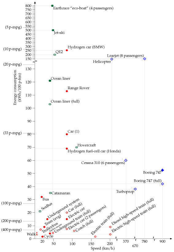
The bicycle is the king of the y-axis, which measures energy efficiency in kWh per 100 person-kilometers, in other words what it takes to move 100 people 1 km down the road (or 1 person by 100 km, 25 x 4 etc). Only the rush hour electric train gives it a run for its money.
40% of all car trips are of bikeable length in the U.S. (< 3 miles), representing 7% of all distance driven.3 This translates to 4 kWh / d or 2% of total consumption. Shifting these trips from cars to bikes would reduce this spending by an order of magnitude. For context, this roughly equals the savings of converting all your incandescent bulbs to LEDs or committing to eat vegetarian for 3 days of the week. Nothing to sneeze at for such modest behavioral changes.
Violet Beauregarde and the crisis of space
Violet Beauregarde in Charlie and the Chocolate Factory chews Three-Course Dinner Chewing Gum despite warnings from Willy Wonka that it was still experimental. Consequently, she becomes grossly inflamed and sends the Oompa-Loompas into an immunogenic tizzy. If instead they had taken Violet’s actions as encouragement to break rank with their eccentric leader and tasted the Three-Course Dinner Chewing Gum for themselves, right there on the at-capacity manufacturing floor, the ensuing mayhem would have resembled rush hour in an American city. Only our car-dependence is much worse.
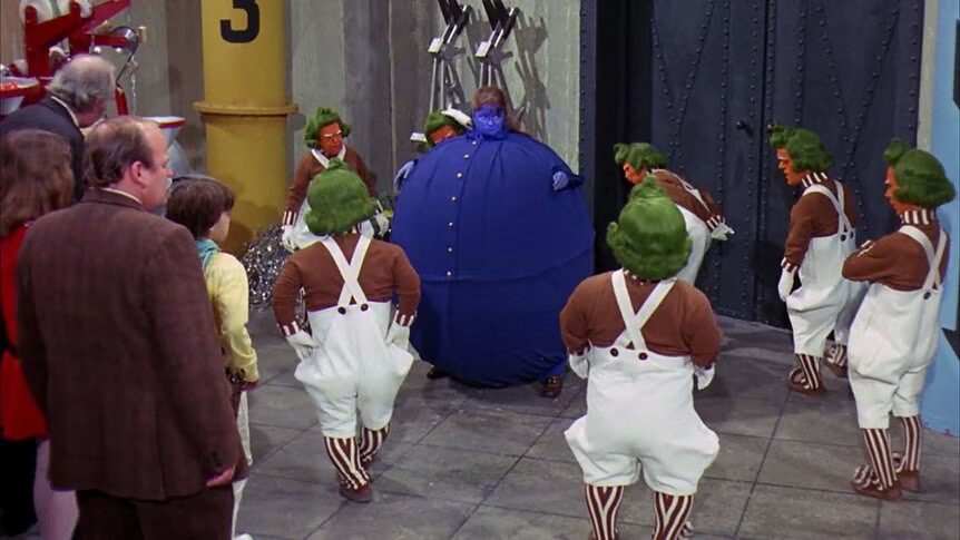
Travelling by car, we expand to 40 times our size!5 And while we shrink down to normal before we go back indoors, our monstrous blueberry carapaces idle for over 20 hours a day. To accommodate cars, our cities have ballooned in size. American cities are 2 times larger than European cities by land area and contain half as many people per unit area.6
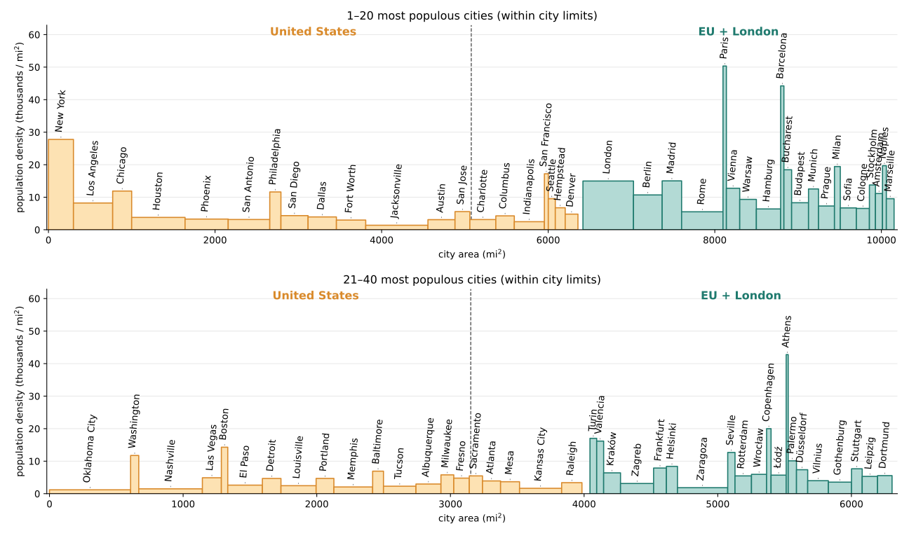
We allot so much space for cars that we are now struggling to find room for people. On average, 22% of land in the city center is devoted to parking lots.7 Multi-lane highways tear through neighborhoods. Traffic is grueling and looms large in the minds of homeowners as they push back on efforts to develop housing. 63% of respondents in a Sacramento survey said their primary concern with new housing was its impact on traffic and parking, far more than mentions of neighborhood character, school overcrowding, or crime.8
Bicycles take up 4 times less space than cars. Even if everyone upgraded to the Urban Arrow Family9, the crown jewel of bakfiet-style e-bikes, their footprint would be nearly 3 times less than a midsize sedan. Trading cars for bikes would relieve pressure on space constraints by multiples while maximizing autonomy and flexibility. Every individual could ride alone when they needed without taking up space for 40. Children could take themselves to soccer.
Other car-centric ideas to save space like carpooling and autonomous vehicles are hard-pressed to achieve these space savings multiples. Vehicles would have to be fully occupied on average compared to the current estimate of 1.5 passengers per vehicle. In theory autonomous vehicles could do better but one wonders if the peak demand during rush hour and consumer preferences will allow it. A sensible estimate is that robotaxis will have usage rates like taxis, 1.2.10 Even with ridesharing offers like Uber Pool and Lyft Line, occupancy barely budges to 1.3.11
The crisis of affordability: cars are just expensive
Cars are expensive. All-in, they cost about $13,000 per year, or roughly 17% of the average budget.12 This makes them the second largest category behind housing and a head of food with no comparison in terms of accommodation or flavor. The median new and used car will run you $50,000 and $25,000, respectively. A sturdy bicycle might set you back hundreds of dollars. You can trade up to an e-bike for single thousands. I’ll let you decide where to put that chunk of change erstwhile tied up in a stuck-in-traffic Toyota Camry.
Patchwork Quilt, U.S.A.
The triple crisis facing American cities has been a long time coming. Adhering to a car-centric pattern of development has seen urban land area grow 1.4 times faster than the population between 1960 and 2020. The average distance driven per person-day has doubled from 20 to 40 miles in that same period.13 Thankfully, support for densification and transit-oriented development is now increasing. Still, the last half century of development has left us with an uphill climb toward healthier cities. Bikes should factor heavily into that end-state, but perhaps as crucially can serve as a stepping stone to ensure we get there. By and large, our sprawling cities are not walkable. We cannot simply fold them up into the walkable size of peer cities in Europe. But take a closer look, as you did through the lens of the map widget, and you realize there is just enough clustering of homes and points of interest, not on the scale of walking, but on the scale of biking to offer an opportunity. A study from the Brookings Institute points toward a similar conclusion. Here, is a summary of the fraction of people within walking and biking distances from “activity centers”, clusters of stores, offices, amenities, etc. in the largest 110 U.S. metro areas.
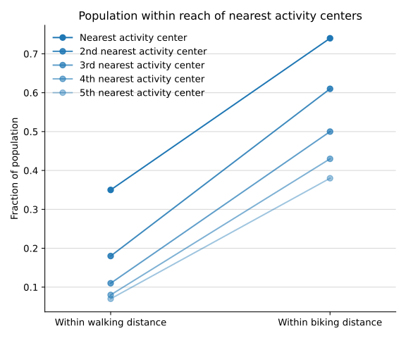
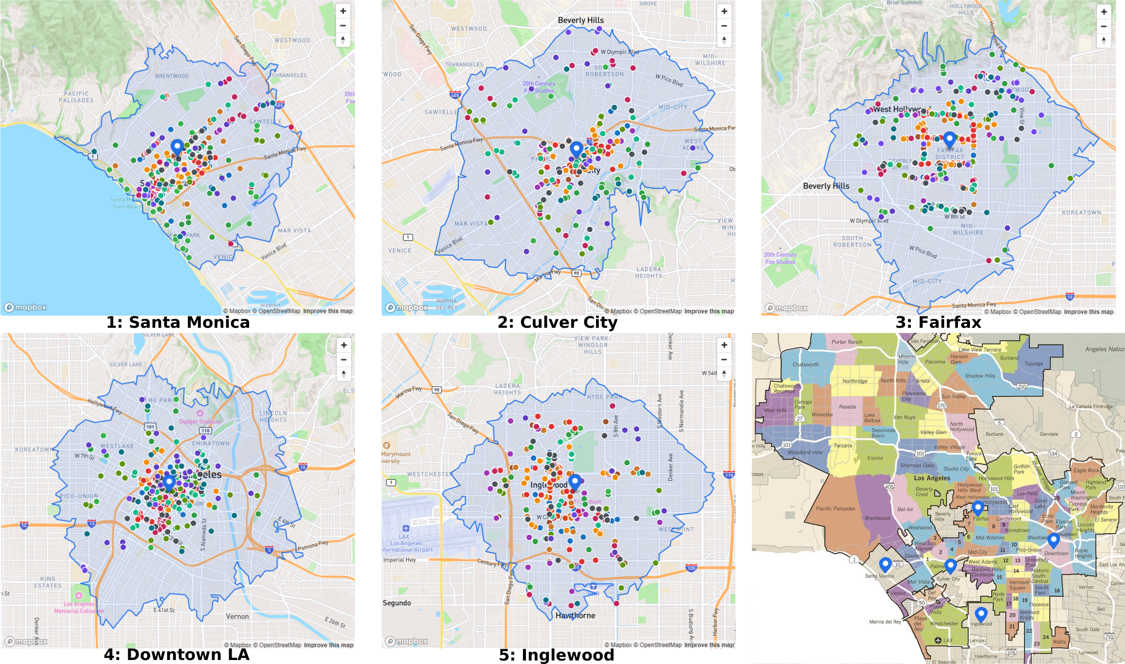
We cannot fold up our cities, but we can knit together their patchwork of bikeable neighborhoods into a colorful and vibrant quilt. Consider Los Angeles, paragon of sprawl and car-centrism, 471 square miles of city. It is also true that 74% of the population lives within 3 miles of 5 separate activity centers, compared to the national average of 38%.13 If tomorrow LA decided to build a comprehensive bicycle network, three quarters of their population would suddenly have car-free access to a wealth of amenities. The construction needs not proceed all at once. City planners could gradually experiment patch by bikeable patch. It would take approximately 17 patches to cover the entire city area, a more manageable number than the 157 patches that walking requires. Here are a few examples to give you a picture. The bottom right image shows where the 5 patches fall on a map of LA neighborhoods.14
I am not against walkability or further densification, but I see the obstacles blocking progress toward this goal as thorny and feeding into one another in vicious ways. Expensive transit construction projects seem foolhardy when passengers may only ride them to pedestrian wastelands. Densifying areas to the point of walkability requires both taking space away from cars and adding more of it for the higher concentration of people whose only recourse is to drive there. No one takes the bus because it’s snarled in traffic. And in our desperation, we become willing to suspend disbelief that robotaxis will so significantly break the mould of homotaxis.
We can turn this vicious cycle into a virtuous (bi)cycle. Bikes are more energy efficient, take much less space, and are radically more affordable than cars. Further densification is not required from the jump. We need only build a comprehensive bicycle network at a cost of pennies and dimes on the dollar per mile compared to car lanes.15 Once patches of bikeable neighborhoods take root, the case for investing in rapid transit lines between them becomes stronger. Less traffic on the road makes way for faster buses. Less required parking would take the edge off challenges to build more housing. Not much convenience is lost. Driving a car within a bikeable region may be twice as fast but after looking for parking, drivers save just a few minutes off the trip. With fewer cars on the road making short trips, drivers who need to travel longer distances will hit less traffic.
Bikes won’t solve everything. One nasty fly in the ointment is the fact that the average American commute is about 16 miles one-way, which makes biking to work a non-starter for most.16 But I hope you’ll agree that bicycles are a serious and bona fide mode of transportation in addition to being a fun way to cruise through the park or get some exercise. Their combination of energy efficiency, space efficiency, and speed relative to walking position them uniquely to catalyze the transition to a new equilibrium, Patchwork Quilt, U.S.A., in which Americans are wealthier in terms of energy, space, and cash, and freer to pursue happiness.
Postscript: actions you can take, within biking distance
Patchwork Quilt, U.S.A. will require building bicycle infrastructure and increasing its use. One feeds the other. There are a number of actions you can take which scale with the amount of time you can shake free from your day-to-day schedule. I can say from experience that getting involved with bike advocacy brings you closer to your neighbors as after all, choices about how to build bicycle infrastructure are specific to where you live. But the community is also global. You’ll start to notice lots of like-minded people when you travel and on the internet. It’s a nice feeling.
Roughly from least to most time intensive:
- Talk to someone else about bikes. Share this article. Share any article or video. There are a lot out there. Off the top of my head: Not Just Bikes, Strong Towns, People for Bikes, Streetsblog, CityNerd, City Beautiful.
- Ride your bike. Find somewhere you could go – a park, café, restaurant, library, your office if you’re lucky – plan how to get there, and go. If you don’t have a bike, check if you can take a bikeshare like Citi Bike, Bluebikes, Divvy, etc. Go when the weather’s nice. Please wear a helmet.
- Ride your bike again. Start thinking about where the most impactful new bike lanes might go. Don’t stop.
- Ride regularly. If that means you must first buy a bike, check Facebook Marketplace for deals. Check out used bicycle shops in your area. Try to save money but make sure you get something sturdy.
- Ride your bike when it’s crappy weather out. (See FAQs)
- Look up or somehow try to find local bicycle advocacy groups near you. I got lucky one day when some dude passed me a business card for the Evanston Transit Alliance.
- Participate in events and meetings for the advocacy group.
- If you’re unlucky but ambitious, start a local advocacy group! I was lucky so I don’t have this experience but if you are interested, email the Evanston Transit Alliance, or some group in a city other than yours, for pointers.
- Figure out how local politics work, even if just a little bit. I’m not exactly a political operator, but over time, I’ve at least learned who my local city council person is, how to contact them, and how to turn up to community feedback meetings. Go little by little. You might surprise yourself.
I see a lot of momentum for bikes out there, so perhaps you will too. I’ve visited or lived in New York City (especially Brooklyn), Boston / Cambridge, and the North Side of Chicago / Evanston, all of which are at various points on a journey toward a comprehensive bicycle network and significant ridership. To achieve this goal will require infrastructure, politics, and cultural change. It will require that we connect with our neighbors and work together. Email me if there is anything you want to talk through.
FAQs
When you’re riding your bike, how do you deal with…
…rain? …cold? …sweat? …darkness? …bike breaks? …carrying stuff? …keeping your clothes clean?
Perhaps in a forthcoming post I will share my personal tips on how to be a regular utility biker. For now, I’ll just link you to The Guardian’s recent article 17
Footnotes
-
3 miles long, in other words, a breezy 20-minute bike ride ↩ ↩2
-
Assuming we all travel by mid-sized sedan at an average occupancy of 1.5 passengers per vehicle. ↩
-
63% of respondents …said their primary concern …impact on traffic and parking ↩
-
Tomer and George. (2023). Building for proximity: the role of activity centers in reducing total miles traveled. Brookings Institute. ↩ ↩2
-
pennies and dimes on the dollar per mile compared to car lanes ↩
-
Patterson. (Thursday, May 14, 2026). A beginner’s bike commuting gear guide: what to buy (and skip) before your first ride. The Guardian. ↩